Sunday, 16 January 2011

Saigon and the Mekong Delta

There are two distinct and very different sides to central Saigon. (Only Government officials and a few people in Hanoi seem to call the city by its official name: Ho Chi Minh City). The old colonial centre is the glitziest and most westernised place we’ve seen in Vietnam, with wide boulevards, an imposing cathedral, opera house and other grand French-built buildings, interspersed with shopping centres and trendy restaurants. At times, strolling amongst the designer boutiques and smart hotels we could have imagined ourselves in Knightsbridge rather than South East Asia if it hadn’t been for the constant torrent of motorbikes on the roads and the 30 degree sunshine.

In smart, modern Saigon there’s no sign of the ancestor worship that we saw further north – where all houses had shrines prominently displayed, and shop owners burned incense and made offerings every night outside their premises. Life is much more hidden from view here than it was elsewhere in the country, with fewer street traders and street-side cafes, and swanky wine bars rather than road-side fresh beer.

This side of the city reflects Saigon’s long-held position as the economic powerhouse of the country. French colonialism was established much earlier in Saigon than elsewhere in the country, and the history of the city and its surrounds have been heavily influenced by foreign trade and engagement, in contrast to the more isolationist North. Also, unlike the North, it has only been Communist only since 1975, and with economic liberalisation starting less than 15 years later, the city was well placed to take advantage and re-establish its thriving economy.

Just a 20 minute walk away though, in the area now dominated by backpacker cafes and tour agencies is a much more familiar Vietnam which, while certainly shabbier than the colonial area was also – to our eyes – much more appealing. Here, amongst the narrow, labyrinthine alleyways we found small cafes, tailors, laundrettes and other “mom and pop” businesses operating out of the front room (complete with ancestral shrine), and living quarters above.


Steve and Janet left us in Saigon after a fantastic two weeks. We are so glad and grateful that both sets of our parents have joined us for parts of our journey, and have loved seeing them and being able to share some of this year with them.


The “American” War seems much more prevalent in Saigon than elsewhere, perhaps because it was here that the Americans and other foreign forces were stationed, with museums dedicated to the war, and war-memorabilia (pens and knick-knacks fashioned from old bullets, flak jackets, and zippo lighters bearing US Army insignia) on sale at market stalls. The War Remnants Museum was one of the more interesting we’ve been to, containing harrowing accounts and photographs. Although an understandably one-sided presentation of the conflict, the museum succeeded in making plain some of the horrors inflicted upon the country and the civilian population.

A particularly poignant section of the museum focused on the damage caused by Agent Orange – the chemical sprayed from the air by the US Army in order to reveal Communist supply lines and deny cover to potential ambushers. Almost 80 million litres were sprayed over 2.6 million hectares, leaving much of Central Vietnam deforested and contaminated. Yet the impacts were not just environmental or immediate: people who lived or fought in affected areas have since given birth to tens of thousands of children born with serious birth defects, often without eyes, limbs or organs, or with oversized heads or serious mental disabilities. We subsequently learnt that shockingly, while compensation has belatedly been paid to US servicemen whose families have been affected, no compensation has yet been paid to any Vietnamese victims.

As the other museums we’ve visited, it was disappointing to see no reference in Saigon made to the Vietnamese who served in the Army of the Republic of Vietnam (ARVN, the army of South Vietnam). Instead, as elsewhere, the museum presented the “official history” that the North saved the South from its imperialist masters, and gives the impression that the ARVN was entirely made up of foreigners. In fact, throughout the war, there were more than twice as many South Vietnamese fighting as Americans, Koreans, New Zealanders, and Australians combined. After the war, tens of thousands of them fled the country, while many of those who remained were placed in “re-education camps,” and they – and their children – allegedly continue to face discrimination from the ruling Communist Party.

While in Saigon we also visited the Cu Chi Tunnels, an incredible 250 kilometre network just 60 kilometres outside Saigon that formed a key site of resistance against first the French and then the Americans. The tunnels served not just as escape routes and ambush points for the guerrilla fighters, but also as dwellings for up to 10,000 people, with additional rooms for use as small factories, kitchens and classrooms. The original tunnels were tiny, designed to be too narrow for Westerners to enter and must have been extremely claustrophobic. For the benefit of tourists, several sections have now been enlarged, so we could take turns squeezing ourselves into the earth and crawling along sections of the network. After hearing more about the horrors inflicted during the War, we were somewhat surprised to be offered the opportunity to have a go firing M16 and AK47 assault rifles. While we found this slightly distasteful and gave the opportunity a miss it was clear that for many of our fellow tourists this was the highlight of the trip.


We’ve spent a very peaceful final few days in Vietnam exploring visiting a small part of the enormous Mekong Delta. In contrast to so many of the places we’ve seen, the Mekong feels incredibly lush and fertile, with bright green paddy fields, and wooded areas of bananas and palms separated by large rivers and countless small waterways. Yesterday we spent the morning on the water, setting off while it was still dark to watch the sunrise over the river before visiting a couple of floating markets where enormous quantities of vegetables and fruit were traded between boats (which advertised their wares by tying them to the tops of tall bamboo canes). Other small boats sold meat or served as small floating cafes serving cooked noodles and other snacks.


In the afternoon we hired rickety bikes and cycled through tiny lanes alongside some of the narrow canals, over wobbly bridges and past small villages. It was a landscape both beautiful and tranquil yet as elsewhere marred by constant littering in the waterways and alongside them. With heavy traffic on the main roads and large scale construction going on across the Delta we worry about the environmental damage being wrought on the area by this rapid change and the long-term impact it will have on the area and its inhabitants. Tomorrow, after a fascinating and very enjoyable four weeks, we’ll leave Vietnam, travelling by boat further up the Mekong to Cambodia.

Monday, 10 January 2011

Central Vietnam: Hoi An and Nha Trang

We’ve spent the last few days in the central provinces of Vietnam, one of the most beautiful but poorest areas of the country, which consist of a narrow strip of a sandy coastline caught between the South China Sea and the Troung Son mountains, which form Vietnam’s border with Laos.

From Hanoi we travelled south on the overnight Reunification Express to Hoi An, the prettiest town we’ve visited in Vietnam. Hoi An, which was then situated at the mouth of the Thu Bon River, developed as a prosperous trading port in the 1600s with quarters dominated by Chinese, Japanese and European merchants. In the late eighteenth century however silt began to clog up the river leaving Hoi An stranded a few miles in land and the town went into decline as trade moved elsewhere.

The decline in trade meant that many of Hoi An’s older buildings were preserved, and then luckily escaped major damage in the French and American Wars, leaving a largely pedestrianised old town and riverfront that retains an antiquated charm and was a wonderful place to spend a few days. The old town streets are an appealing mix of original wooden merchant houses, French colonial buildings, and Chinese assembly halls. Many of the buildings now house a myriad of tailoring and shoe making shops, restaurants and street food stalls selling traditional Vietnamese noodle soup and bia hoi (the fresh beer which was even cheaper here than Hanoi at only 10p a glass!), all of which we collectively made the most of.


Many of the waterfront merchant houses in the town have been restored and were fascinating to wander around. Typically as narrow as only 10 foot wide but up to 150 foot deep (a style which is still evident in many modern Vietnamese buildings), these long thin buildings provided a family home, a shop space at the front, a small outside courtyard in the centre and direct access to the river at the back so merchandise could be hauled upstairs safe above the annual floods that still blight the town. As recently as November 2010 the three streets closest to the river were submerged and we saw several buildings still evidently flood damaged, and even now in the dry season the river still over ran its banks most evenings. Our concerns for the future of this pretty town – and for Vietnam as a whole – were reinforced when we learnt that a 2007 report for the World Bank had concluded that Vietnam will be one of the five countries worst affected by rising sea level, with any rise over a metre “potentially catastrophic,” flooding over 5% of the country, including some of the most populated and economically useful areas, directly affecting over 6 million people.


Forty kilometres outside Hoi An, in an isolated rural setting, are the ruined Hindu temples of My Son, the religious and spiritual centre of the Champa Kingdom which covered much of central Vietnam from the 4th to 11th Century AD. We arrived early in the morning to miss the tour groups and spent a fascinating few hours alone wandering around the temples. Many are relatively well preserved and you can easily climb into their chimney like interiors. The external walls have elaborate carvings of the Hindu god Shiva, elephants, monkeys and coconut trees intertwined with real tree roots and vegetation. Sadly, although sections of the temple complex are well preserved, a number of temples were bombed by the Americans during their carpet bomb campaign which affected much of central and northern Vietnam, leaving only piles of crumbling bricks.


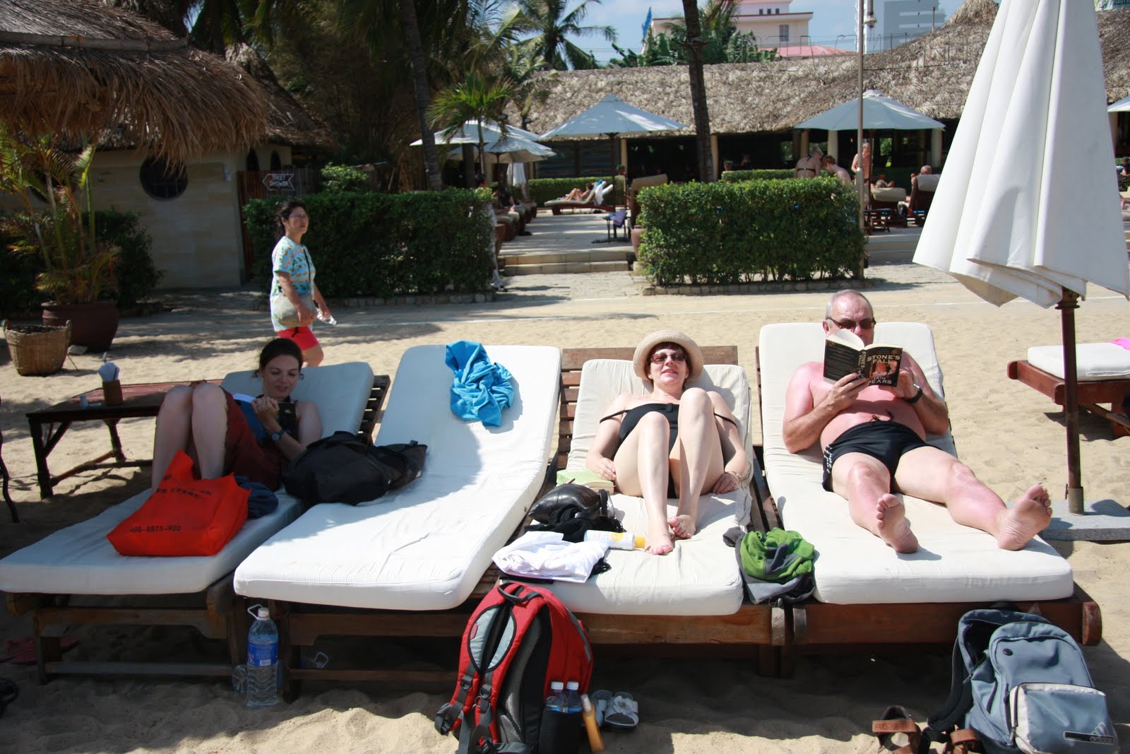
After spending a couple of afternoons on the quiet Cui Da beach outside Hoi An, we moved on to Nha Trang, the beach capital of Vietnam. After a cramped and uncomfortable overnight bus journey we felt in definite need of some rest and relaxation and thankfully luck was on our side, and we spent a very pleasant three days enjoying lots of sun from the loungers at a luxurious beach club with its own micro brewery.

Friday, 7 January 2011

Hanoi and Halong Bay

Even experience of Mongolia’s eratic driving and two months in China hadn’t prepared us for the unique chaos of Hanoi’s roads: a constant tide of motorbikes and scooters weaving in amongst each other, with no apparent traffic rules other than a seeming requirement to beep almost constantly. Crossing the road involves taking a leap of faith – stepping off the curb and just walking slowly and steadily and trusting that the bikes would flow round you. Motorbikes, which amazingly make up 98% of the traffic on the road, are used to carry anything and everything from a family of five to a large kitchen table, a new flat screen TV or even a live water buffalo. It’s got to the point where it looks odd seeing a bike with just one rider on it.

Kieran had been to Vietnam and Hanoi almost 10 years ago, and the city was largely as I remembered it, although with more traffic, but with fewer pushbikes and more motorbikes. Crash helmets have also arrived, required by law since 2007, before which over 30 people a day had been killed on the city roads. There are more western tourists too, and the cycle rickshaws which used to be commonly used as cheap taxis now seem reserved only for tourist use and are available for hire by the hour. But the feel and the atmosphere of the city have remained much as I remember them.

Despite the unnerving traffic we enjoyed our time in Hanoi and found it a fun and vibrant city: the pavements crowded with streetside cafes with tiny plastic chairs and tables selling fried dough, noodles, snails, and fresh beer (at only 13 pence a glass much the cheapest drinks we’ve had on this trip and a great way to start the evening); lively covered markets; and the busy old town with streets wholly devoted to selling one product or another, with one street selling just sunglasses, and another just shoes or fabrics, engraved headstones or motorbike parts.


We were met in Hanoi by Steve and Janet, Rachael’s parents who have joined us for the two week journey from Hanoi to Saigon. Together we spent a very enjoyable 4 days exploring the old town and the French quarter. Unlike in China, which seems to be intent on demolishing or hiding much of its history, Hanoi’s history is well preserved and documented. The French influence on the city is immediately apparent from the beautiful –if now dilapidated – colonial buildings, complete with balconies, verandas and wooden shutters. The city houses several interesting museums including the old French prison later used by the North Vietnamese to hold captured Americans including John McCain, which helped us learn more about the Vietnamese take on their struggles for independence over the last century against the French, Japanese and Americans. And then there’s Ho Chi Minh’s mausoleum, where Ho (like Lenin) remains on public display against his last wishes.


From Hanoi we travelled to Halong Bay, a spectacular marine landscape of thousands of limestone islets that rise out of the calm turquoise sea, concealing wonderfully secluded lagoons and coves. We spent a day on board an old fashioned Chinese junk, sailing amongst the islands and going swimming off the boat before seeing the New Year in in style on board.


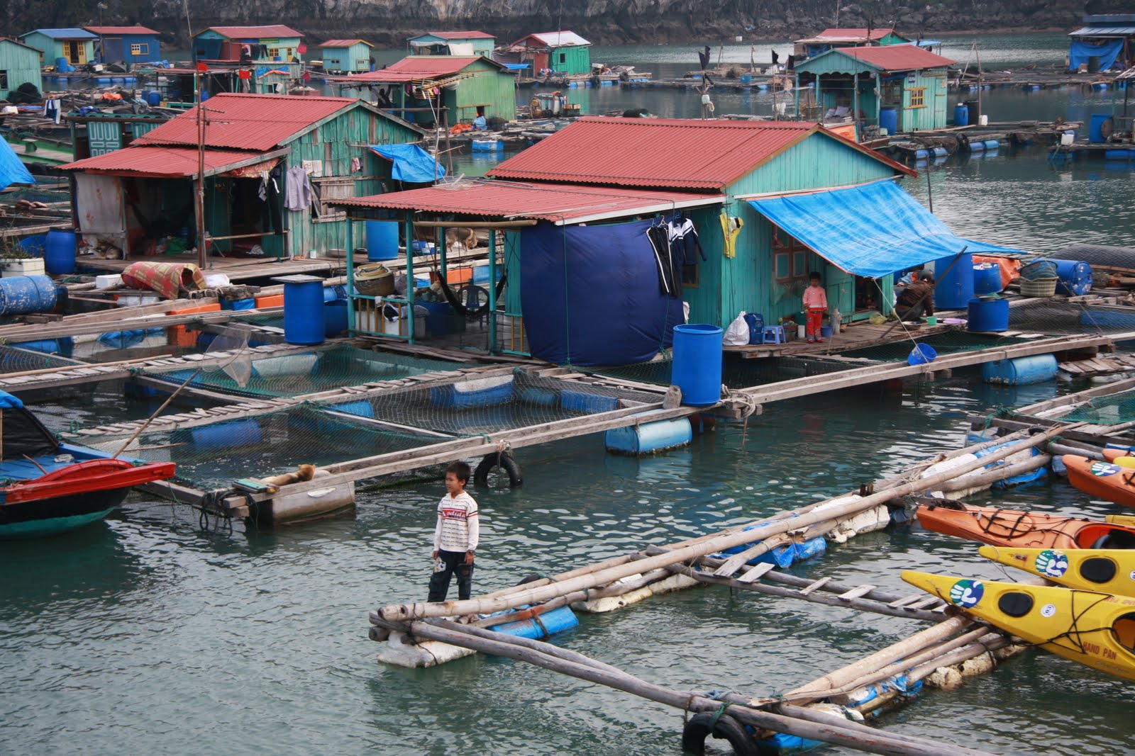
The next day we explored more of the Bay by kayak, visiting quiet beaches and shallow areas the larger boats couldn’t reach and also some of the many tiny fish and mussel farms that are dotted around the Bay and where whole families and communities live permanently, eking out a living from their floating bamboo platforms.

Saturday, 25 December 2010

Christmas in Sapa, Northern Vietnam

For our first two days in Sapa, an old French hill station in Northern Vietnam, we couldn't see much of the town or the surrounding countryside thanks to the thick mist and persistent drizzle that enveloped us. But unlike in China there were at least Christmas decorations up in the hotels, log fires and western food available in restaurants, and English language tv showing endless ‘80s Christmas films, so we’ve belatedly started feeling a bit more festive.

Luckily the fog lifted on Christmas Eve and we spent a great day and a half walking through very beautiful if very muddy terraced hills and paddy fields, spending the night of Christmas Eve in a homestay. Generally the food on the walk was delicious though our Christmas lunch was a rather underwhelming bowl of instant noodle soup, so we’re off out now to find somewhere to spoil ourselves with wine and pizza. Merry Christmas all!

Wednesday, 22 December 2010

Tibet - Lhasa and Everest Base Camp

We’ve both been long fascinated by Tibet and its history, and so the idea of coming here had been one of the parts of our trip we were most looking forward to. Because of the political situation, foreigners need multiple permits just to enter the region, have to be accompanied by a guide to visit any site of interest and at all times outside Lhasa, and are banned from most areas. Yet these restrictions didn’t lessen our enjoyment of Tibet, and our time there proved to be everything we’d hoped it would be and a real highlight of our trip so far.

We’d originally hoped to be able to travel directly to Lhasa from northern Yunnan, where we’d been to hike Tiger Leaping Gorge and which is on the border of Tibet, but instead – with eastern Tibet closed to foreigners – we embarked on a 4 day, 5000km journey involving 3 trains and a stop-over in Chengdu just long enough to visit the Giant Pandas and the tiny panda cubs at the breeding research centre. Reluctantly, when returning to Yunnan we chose to fly rather than repeat the overland journey and so took our first flight since we arrived in Bergen, 15,000 miles ago. Amazingly, a journey that had taken over 60 hours by train took less than 6 hours in the air.

We spent four days in and around the capital Lhasa, exploring the old part of town and visiting several monasteries and temples, as well as the fabulous maroon and white Potala Palace. The Potala was the traditional seat of political and religious authority in Tibet, which stands on a hill in the centre of the city and is its focal point. After the hustle and bustle of most Chinese cities, Lhasa felt delightfully small and quiet (there are just 800,000 inhabitants) and was a fabulous city to wander on foot. And while visiting in winter meant enduing cold weather (typically between -10 and 8 degrees in Lhasa and a lot colder outside the city), it also meant we enjoyed clear blue skies everyday and got to see the region at a time when there are almost no foreign or Chinese tourists around and instead Lhasa is filled with pilgrims from across the country, and we spent hours just people watching.


Although a part of the People’s Republic of China since 1950, Tibet feels like a separate country. Tibetans tend to be taller and look very different from the Han Chinese, with wide, high cheekbones, and darker skin; they dress differently too, the men in thick fleece lined cloaks worn off one shoulder and with knee length sleeves, their hair often long and sometimes plaited or topped with cowboy style hats; the women in dark skirts and striped aprons, with coloured thread or coral and turquoise beads woven into their hair, often – incongruously – with a North Face jacket over the top; and they speak an entirely different language. They were also some of the smiliest people either of us had ever seen and everywhere we went we were greeted with a grin or tashi delek (hello).


The signs of Chinese control however are obvious: Chinese riot police patrol the streets and sit up on the tops of the buildings pointing video cameras and guns down at the people below; a Chinese flag flies the Potala Palace and from every public building; and the Tibetan flag and images of the Dalai Lama are banned while the majority of Tibetans are forbidden from travelling (even to the rest of China). In addition, most of the monasteries in the country were damaged or destroyed during the Cultural Revolution and its only in the last twenty years that Tibetans have been able to openly worship again. Even so, the blurb on our various monastery entrance tickets heralded the decline in the number of monks since “the Liberation.”

The Tibetan monasteries we saw were sprawling walled complexes, often built into the valley walls and resembling fortresses as much as religious buildings. While the outside of the temples were relatively plain, with whitewashed or maroon walls and red drapes above the windows, the interiors were decorated with enormous and brightly coloured murals of various deities. The temples were also dark – lit mainly by yak butter lamps, topped up by pilgrims carrying a tub of butter and a spoon or a flask of oil – and crowded with models of deities and past lamas, photographs of abbots, scarves, incense, pilgrims and their offerings all competing for space.


Visiting the monasteries also gave us an insight into Tibetan Buddhism, which proved very different from what we’d expected. The Tibetan form of Buddhism incorporated pre-Buddhist religious practices (some of which, like offering alcohol to the sky before drinking, we recognised from Siberia and Mongolia) and figures, creating a religion with hundreds of deities very different from that practiced in southern India and South East Asia.

Rather than spending time in quiet contemplation or meditation as we’d anticipated, prayer seems to be done through motion: people complete kora (circuits of religious buildings), the most devout doing so by prostrating themselves all the way round while others prostrate themselves repeatedly in front of the temples; inside pilgrims push their way into chapels to make a quick offering of yak butter, barley or money and then move immediately on to the next chapel; people walking down the street click rosary beads or spin handheld prayer wheels inscribed with mantras that are carried to heaven by the motion, while at monasteries larger prayer wheels are set into walls or mounted in lines on posts to be turned by passers-by.


At one of the monasteries we visited, we watched monks “debating” in a walled garden. To our surprise, rather than a theological discussion however, the debate involved teenage monks testing each other on their knowledge of scripture, with correct answers rewarded by a clap and much jubilation, while incorrect answers were chided and ridiculed.


Architecturally, the highlight of our time in Lhasa was visiting the Potala Palace, Tibet’s most iconic building which dominates the city from its hilltop position. It was fascinating to see the personal quarters of the current Dalai Lama, where he lived and studied until going into exile in 1959, as well as the enormous gold and jewel encrusted funeral stupa (tombs) of the previous 13 Dalai Lamas. It’s continued symbolic importance was evident from the number of pilgrims completing kora of the Palace, yet it was sad that this amazing building is no longer used as intended, with just a handful of rooms open to the public and the others empty and closed.


We left Lhasa for a 4 day road trip to Mount Everest Base Camp along the Friendship Highway, the 1000km long road which links Lhasa and Kathmandu at an altitude of over 4000m for most of the way. The drive was exhilarating as we meandered through wide open valleys and deep narrow gorges, over six mountain passes ranging up to 5200m, and past spectacular scenery including the holy and bright blue Yamdrok-Tso lake and the immense glacier on Mount Nojin Kangstang (7191m). Each of the passes and holy places was covered in a mass of cotton prayer flags, each the colour of one of the five traditional elements (red; fire, white: air, green: water, blue: sky and yellow: earth) and covered in mantras and prayers to be carried to the heavens by the wind.


The landscape of the plateau was incredibly beautiful if harsh and forbidding, a crumpled and mountainous mixture of bare pastel coloured sandstone slopes and rocky scree, with the highest peaks capped by snow and ice. Throughout the drive we saw almost no vegetation and the several rivers and smaller lakes we passed were all frozen. On the third day of the drive, the wind rose and whipped up a number of huge dust storms, at times blocking out the view entirely and limiting visibility to a few feet.


Despite the harshness of such a cold and dry environment, and the tough life that the rural Tibetans must lead, the valleys we passed through were well populated, with most of the valley bottoms were divided into small fields (all bare earth in December). As well as growing barley, most farmers keep goats, sheep and yaks. Amazingly, yaks have adapted to the high altitude by developing such a high red blood cell count that they can die if they go below 3000m.

Every few miles we passed a small hamlet of squat, rectangular, single-storey buildings built of stone or mud brick. Most of the houses were crudely whitewashed and so stood out against the sandy coloured landscape, with their windows picked out in black paint and thick blue and white blankets embroidered with Buddhist designs hanging in front of the doors. Stopping at one of these houses for a cup of cha ngama (sweet yak milk tea) became one of the highlights of the trip. And whilst signs of modernity were clear in the countryside and on the Friendship Highway –Toyota Land Cruisers, electricity pylons and satellite dishes all abound – pony and traps and tractors pulling wagons full of people still dominate the roads.


We broke the journey by visiting Shigatse and the Tashilhupno Monastery, the traditional seat to the Panchen Lama, the most important Lama in Tibet after the Dalai Lama and traditionally the scholarly leader of Tibetan Buddhism. With images of the Dalai Lama banned photos of the 10th Panchen Lama (now deceased) are everywhere in Tibet: in religious buildings, hotels, cafes and people’s homes. At the monastery we spent a very pleasant afternoon completing a kora. We also visited Gayntse and the Palcho Monastery, which was built in 1418, contains a seven floor stupa with 108 chapels (the largest in Tibet) and was one of the only monasteries in Tibet to survive the Cultural Revolution.


By the middle of our second day we had our first glimpse of Everest (8844m). Its snowy pyramid shaped peak soared above the other mountains in the same range, even though four of them also topped 8000m. As we neared the mountain, the number of military check points increased. Apparently Everest is a target for protests so the Chinese have a strong military presence in the area but the stopping and starting gave plenty of opportunities to get out the car and stare in wonder in at the Himalayas as they basked in bright blue cloudless skies. As we got closer we gradually narrowed in on Everest and when we finally arrived at Rongphu Monastery (the highest Monastery in the world at 5150m and where we were to spend the night), the deep valley cut the other peaks from sight leaving uninterrupted vistas along the valley to Everest’s dramatic North Peak. We walked the final two hours to the Base Camp and amazingly had the Base Camp to ourselves and could only stand in awe, and slightly out of breath, looking at the summit as the snow and cloud blew off it in the afternoon heat.


As soon as we returned to the Monastery and the sun went down we could see why it was low tourist season: no heating, no electricity, no running water and a night time temperature of minus 25 degrees centigrade. But our room had magnificent views of the peak, which we never tired of looking at. We made it through the night relatively comfortably thanks to our trusty down sleeping bags and returned to the Base Camp the next morning in time to see the sun rise, a fitting end to our time in Tibet.

Yunnan Province

Our spirits rose as soon as we reached Yunnan Province in the south west of China to find – for the first time since Beijing – clear blue skies, sunshine and good visibility: such a joy after four weeks of smog, haze and cloud. And even with a 50 hour journey to get here, involving a train and seven buses, each one a little more crowded and slower than the last, we’re so glad we came to this part of China.

We spent several days exploring the area around Shaxi, a once important town on the Tea Horse Caravan Trail. The Trail, which stretched from Burma to Northern India, was used to carry tea, sugar and salt from the lowlands to trade for horses and other goods from Tibet, Nepal and India for well over a thousand years, from the Seventh Century until 1949, although it went into decline from the mid-Nineteenth Century. As well products, people, ideas and beliefs also travelled along the Trail, contributing to the enormous ethnic diversity in Yunnan – China’s most diverse province – and bringing Buddhism to Burma. Now however little of the trail remains, most having disappeared under concrete or jungle, or been washed away in the rains.


With the collapse of the caravan route, Shaxi was left isolated by a combination of mountainous terrain and poor roads and it wasn’t until 2002 when it was identified as the best preserved caravan town of the entire trail that foreign investment and tourists started to arrive, and with Swiss money and expertise the town’s old buildings were beautifully restored. We stayed in one of the restored buildings – a caravan inn on the town’s tiny main square, where our bedroom was one of the original horse pens – definitely one of the more beautiful and interesting places we’ve stayed.

The architecture in and around Shaxi was also amongst the most interesting and beautiful we’ve seen in China, in stark contrast to the (partially) tiled concrete and breeze block that dominates most Chinese cities. Almost all the buildings, including our hostel, were built of mud bricks that glow honey colour in the sunshine. The majority are two storeys high, and built around an internal courtyard so that, like traditional Arab houses, they face inwards, with rooms opening out onto the courtyard rather than onto the street. The alleyways between the houses are narrow, and the external walls of the houses are blank, interrupted only by the doorways. The lower floor rooms tend to be used for animals and storage, with corn, chilis and grain laid out to dry on the floor of the courtyard, and the upper floor rooms used for living quarters.

The key social and economic event in the life of the normally sleepy town is the Friday market, when villagers from the surrounding countryside come to buy, sell and trade. Most of the shoppers – the majority of whom were women – seemed to be wearing their smartest clothes, with two distinct styles dominant: either brightly coloured embroidered blouses and head-dresses, worn above multi coloured skirts and leggings tucked in to thick socks, or the more androgynous and sombre coloured outfit of flat Mao cap, waistcoat worn over a (sometimes floral) shirt and neatly pressed suit trousers.

We spent an interesting few hours browsing at the market and then joined four Yi women who – shopping done – were walking back to their village in the mountains and had offered to guide us into the hills. Although between the six of us we knew only a handful of words in each others’ languages we walked together very amiably and managed to communicate quite well with a combination of mime and our pointing at words in our phrasebook. They clearly found the idea that we wanted to walk all the way into the mountains, camp, and walk all the way back down the next day absolutely hilarious, but were happy to help.


The path was steep and rocky, and we were glad that our guides – all carrying bulging wicker baskets on their backs – were as keen on taking regular rests as we were. A short way outside Shaxi the youngest of the women who looked about 17 dived into a bush by the side of the path and emerged with a pair of battered canvas shoes – clearly her country shoes – which she put on in place of her smart fake converse (town) shoes which were added to her wicker basket, presumably to be kept clean for her next visit to town. A little while later we were joined by the two sons of one of our guides who were on their way home from school in Shaxi. As it’s a 3-4 hour walk between the mountain villages and Shaxi, most children from the hills board at the school during the week and only go home at weekends.

It was dark by the time our guides indicated that we should leave them and find somewhere to camp, but luckily after the Maclehose Trail we were used to putting our tent up in the dark. The stars that night were stunning – some of the brightest and clearest we’ve ever seen – and we lingered outside looking up at them for as long as we could bear the cold. Amazingly, despite the cold, we slept well in our sleeping bags and woke just as it was getting light to find the world outside had turned white under a thick layer of frost and even the inside of the tent was coated in ice where the condensation from our breath had frozen. We walked for a couple of hours around the plateau at the top of the mountain, marvelling at the views of snow capped mountains twinkling in the sunshine – our first Himalayan peaks of this journey - and amazed at how many small villages there were up there. Then we turned around and started the long walk back down to Shaxi.


Our last full day in Shaxi we set out to walk one of the few remaining sections of the Tea Horse Trail to a village, Ma Ping Guan, near the old (now flooded) salt mine that brought Shaxi its wealth and status. This time our guide was the primary school teacher at Ma Ping Guan, who explained that there were 14 families and 120 inhabitants in the village, and that he taught the ten children under the age of 11, after which age they transferred to the school in Shaxi.

As on every other day the weather was flawless, and the views out over the wooded hills, the deep gorges and back to the wide flat valley behind us were stunningly beautiful. In the sunshine it must have been 20 degrees, but the sun wasn’t strong enough to warm the air or the ground so that in the shade the ground stayed frosty and the air cold. It took us almost 9 hours to walk to Ma Ping Guan and back. On the way back, after our guide had left us, we passed only a handful of people, all local villagers felling wood or carrying it back to their village, and we realised that these walks around Shaxi have been the only times in 7 weeks in China we’ve been alone. And as we walked the sometimes steep, uneven and heavily worn earthen trail we struggled to imagine what it must have been like for the tea porters who used to walk it, carrying more than their body weight in tea.

From Shaxi we travelled further north to the beautiful if very touristy old town Lijiang, which we used as a springboard to access Tiger Leaping Gorge. The Gorge is apparently one of the deepest in the world, with an almost sheer drop of over 3900m from the summits of Yulong Xueshan to the east and Haba Shan to the west down to the river below, and the two day hike through it is reportedly China’s finest. The trail climbed steeply at first and then clung to the edge of the gorge over a kilometre above the water, with stunning views all the way of eight of the rocky, snow capped peaks of Yulong Xueshan, which looked almost within touching distance the gorge is so narrow in places. After the first hour or so we even escaped the noise of the construction coming from the road building in the valley bottom, so that the only sounds were the river far below, the wind blowing through the bamboo, and the ringing of goat and horse bells in the distance.

Tuesday, 7 December 2010

Guangxi Province in Southern China


The local tourist board describes the area around Yangshuo as the world’s single most beautiful natural tourist attraction. While that’s overselling it, this sub tropical region is certainly lovely and very beautiful, if undeniably touristy. Indeed, Yangshuo seems to be the Western traveller capital of China and is packed full of cafes and bars holding Happy Hours and selling banana pancakes and Oreo milkshakes. And it’s easy to see why the area has become so popular. Yangshuo has a dreamy and lush green landscape, with thousands of dramatic limestone spires rising out of the otherwise flat land around the Li River, and which looked particularly otherworldly in the mist that dominated the skies during our time here.

The reportedly 2000 limestone peaks in and around Yangshuo were formed as a result of erosion from carbonic acid and the erosion opened up cracks in the limestone, which widened to form caves, the tops of which eventually collapsed leaving just the tall sides standing.

Still seeking respite from urban China, we opted to stay a short walk outside town in a quiet guesthouse set amongst paddy fields which was lovely. We’d hoped to try rock climbing but unfortunately it was too wet, so instead we went for long walks and cycle rides in the countryside, went for invigorating early morning swims in the river, and took a boat trip down one of the most dramatic sections of the gorgeous Li River, past the landscape featured on the 20RMB note.

Also in Guangxi Province we visited the staggering Dragon’s Backbone Rice Terraces, carved into hillsides rising over 1000m: an amazing feat of engineering and endeavour which must have taken decades and thousands of hours of work to cut by hand. China is the largest rice producer in the world with Guangxi one of the most productive areas of the country. In total, China produces around 26% of the world’s rice (187 million tonnes in 2007), of which most is consumed domestically.. Amazingly however, the vast majority of this agriculture is carried out on a very small scale, with China’s agricultural land famed by around 200 million households, each with an average land allocation of just 0.65 hectares (1.6 acres).

Even now, visiting at the “wrong” time of year (after the harvest and before the fields are flooded) the terraces were stunningly beautiful – like an enormous Andy Goldsworthy strectched across the mountainside. And visiting in November did mean that for the first time in China we saw almost no other tourists, not even the domestic Chinese tour groups that we’ve seen everywhere else with matching baseball cap wearing tourists and megaphone wielding tour leaders and who seem to outnumber us Western tourists about 50 to 1.

We decided to stay overnight at the terraces and found a guesthouse with fantastic views out over the terraces and the small village of Tiantouzhai, down into the valley below, and spent a lovely evening sitting on the terrace enjoying a beer and watching darkness fall and the stars come out.